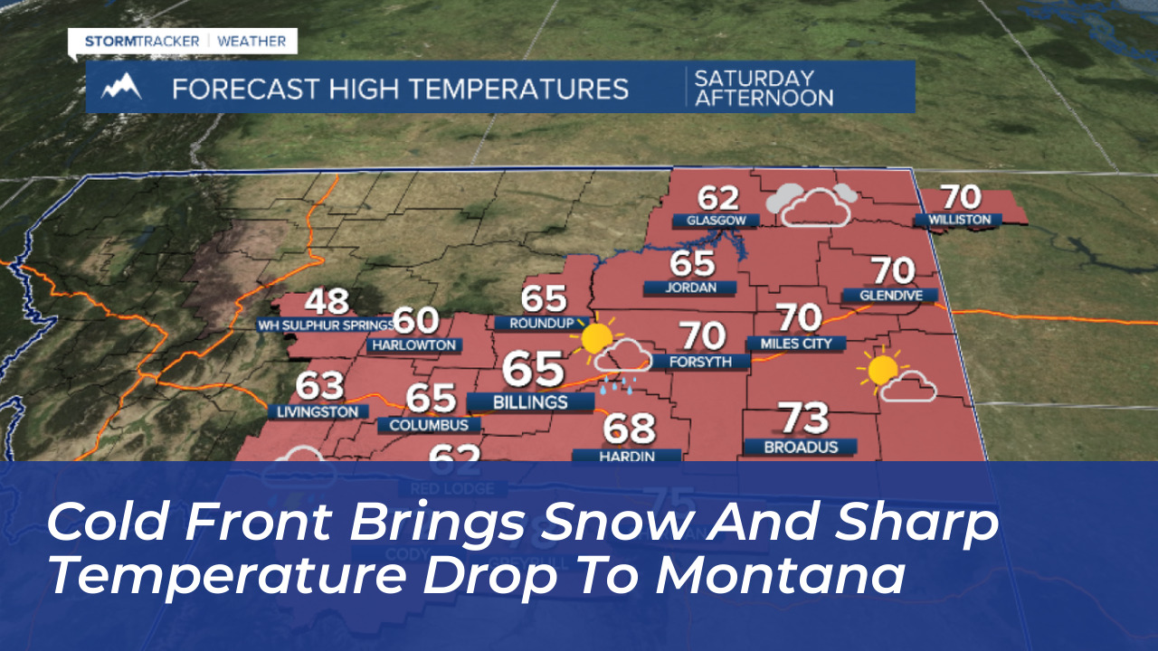

A dramatic weather shift is underway across the northern Rockies as a powerful cold front and low-pressure system sweep through Montana and northern Wyoming. After experiencing record-breaking warmth and unseasonably high temperatures that elevated wildfire risks, residents are bracing for a severe taste of winter over the weekend.
Rapid Temperature Drop and Fire Danger
According to forecasts from KTVQ and National Weather Service meteorologists, Friday’s unusually warm conditions and gusty winds pushed many areas in southern Montana and northern Wyoming into near-critical wildfire conditions. Red Flag Warnings remained in effect through Friday evening as strong winds exacerbated dry terrain. However, that warmth is quickly giving way to an aggressive cold front.
Forecasters note that the incoming system will trigger a drastic 30- to 40-degree temperature swing. Weekend temperatures are projected to plunge 15 to 20 degrees below seasonal averages, bringing a stark reality check after weeks of unseasonably mild weather.
Rain, Wind, and Accumulating Mountain Snow
The cold front is introducing widespread moisture, shifting precipitation from rain showers and isolated thunderstorms to accumulating snow late Saturday and early Sunday. National Weather Service Meteorologist Trent Smith described the weather system to Montana Public Radio as bringing “a lot of moisture, a lot of cold air and a lot of wind to the region.”
- Higher Elevations and Passes: Mountain areas along the Continental Divide could see up to a foot of snow, while mountain passes face slick and slushy travel conditions through the weekend. High peaks of the Bitterroot and Sapphire ranges anticipate up to 9 inches of early-season snow.
- Lower Valleys: Valleys east of Highway 93 can expect 1 to 3 inches of slushy accumulation from Saturday night into Sunday. While the Missoula and Bitterroot valleys may experience scattered rain mixing with snowflakes, significant accumulation in lower elevations is limited due to warm ground temperatures and high sun angles.
- High Winds: Gusty northern winds reaching up to 40 mph are developing in the Flathead and Mission valleys on Saturday night, creating choppy conditions on Flathead Lake before pushing into the Missoula area.
Winter Weather Alerts and Hard Freezes
Weather authorities have issued Winter Weather Advisories for lower elevations across much of western and central Montana. Meanwhile, Winter Storm Warnings remain in effect for mountain areas from Saturday evening through Monday morning.
As the storm system exits the region late Sunday night, a hard freeze is anticipated by Monday morning, with temperatures dropping well into the 20s. Residents are advised to protect vulnerable plants, winterize outdoor pipes, and exercise caution on slick mountain passes. While temperatures are expected to rebound into the 50s and 60s next week, the unseasonably warm upper-70s days of early autumn have officially come to an end.