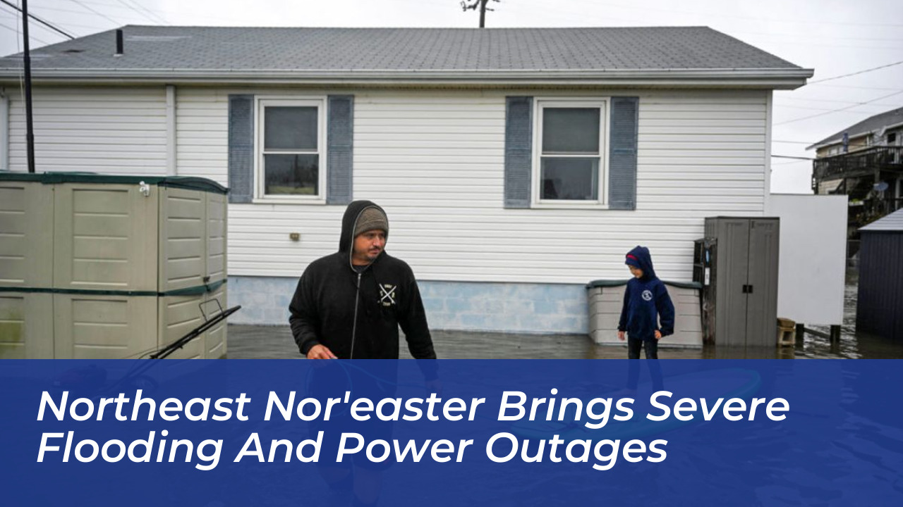
A powerful and anomalous early season nor'easter is currently battering the U.S. Northeast, bringing severe coastal flooding, gale-force winds, and widespread infrastructure disruptions. Spanning from the Mid-Atlantic coast up through Maine, this weather system places tens of millions of residents under various weather advisories, warnings, and watches. Unlike standard winter events, this September occurrence catches coastal communities off-guard while trees remain fully leafed, compounding the vulnerability of local power grids and beachfront properties.
- Introduction to the September Nor'easter Impact
- Severe Coastal Flooding and Community Impacts
- Power Outages, Infrastructure Strain, and Foliage Risks
- Travel Disruption, Event Cancellations, and Economic Fallout
- Meteorological Mechanics of September Nor'easters
- Frequently Asked Questions
- What is a nor'easter?
- Why is this September nor'easter particularly dangerous?
- How long is the storm expected to last?
- What areas are experiencing the worst flooding?
- How should residents prepare for extended power outages?
Introduction to the September Nor'easter Impact
The National Weather Service notes that the storm system is intensifying rapidly, anchored by persistent northeast winds driving water into back bays and tidal waterways. Combined with astronomical high tides driven by a full moon, the storm surge creates hazardous conditions reminiscent of historical storm events. State officials across New York, New Jersey, and surrounding areas have declared states of emergency to mobilize resources swiftly and protect vulnerable civilian populations.
Tens of millions of residents from the Mid-Atlantic to Maine currently remain under active weather advisories, warnings, and watches. This widespread reach highlights the sheer scale of the system, which formed unusually early in the autumn season. While meteorological teams track these developments hourly, local municipalities work around the clock to distribute sandbags and reinforce coastal defenses.
Emergency management directors coordinate closely with state police to monitor flash flood prone zones continuously. National Guard units stand ready with high-water rescue vehicles to assist trapped motorists.
Severe Coastal Flooding and Community Impacts
Coastal sectors in New Jersey and Delaware face the brunt of the storm surge. In towns like Surf City and Manasquan, floodwaters have breached roadways, isolating neighborhoods and inundating residential structures. Municipal leaders report that streets are entirely impassable, with water levels reaching up to six feet in specific low-lying pockets. In Sea Bright, New Jersey, local officials draw direct comparisons to the destructive flooding witnessed during Hurricane Irene in 2011.
High surf, severe beach erosion, and surging tides continue to threaten beachfront infrastructure across the tri-state area. In New York, Long Island communities such as Freeport are actively constructing temporary sand walls to shield residential zones from advancing tide waters. Meanwhile, urban areas like New York City experience localized street inundation, prompting extreme caution from transportation departments and emergency management services.
Over 31 million people remain under active coastal flood alerts as conditions persist. Wind gusts have reached up to 74 mph in localized coastal monitoring stations, rivaling hurricane-force measurements. Rainfall totals of 3 to 5 inches are projected across portions of Long Island and southern New England, further compounding runoff issues in saturated river basins.
Coastal property owners utilize heavy-duty pumps to clear basements as saltwater invades private foundations. Municipal sanitation crews deploy specialized vacuum trucks to drain blocked storm drains rapidly.
Power Outages, Infrastructure Strain, and Foliage Risks
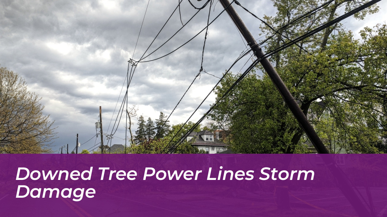
High winds and saturated soils combine to create hazardous conditions for regional power grids. More than 70,000 customers lost electricity early in the weekend, with outages concentrated heavily across New Jersey, New York, Connecticut, and Massachusetts. Utility companies mobilize emergency repair crews, but hazardous field conditions often delay immediate restoration efforts in rural and suburban enclaves.
Meteorological experts highlight that the timing of this storm presents unique botanical challenges. Because deciduous trees retain their full canopies in September, heavy winds exert significantly more torque on branches and root systems. This increased wind resistance multiplies the frequency of downed tree limbs, which subsequently snap power lines and block arterial roadways.
Utility crews face extended repair windows as long-duration gale-force winds persist over a multi-day period. Because saturated ground weakens root system stability, trees continue to topple long after peak rainfall rates subside. Power companies advise residents to stay at least 35 feet away from any downed power lines and report hazards immediately.
Substation transformers experience heavy strain from surging electrical loads and wind-blown debris impacts. Line workers operate in hazardous buckets while battling driving rain to restore primary transmission lines.
Travel Disruption, Event Cancellations, and Economic Fallout
The severity of the nor'easter forces sweeping cancellations across the entertainment, sports, and transportation sectors. Major airports in the Northeast, including Boston Logan International Airport and John F. Kennedy International Airport, report dozens of flight cancellations and extensive delays. Passengers check carrier updates frequently as ramp operations face suspension during peak wind gusts.
Ferry services connecting mainland Massachusetts and Rhode Island to offshore destinations like Nantucket, Martha’s Vineyard, and Block Island are completely suspended due to choppy waters and high winds. Amtrak has also canceled select routes impacted by downed wires and weather hazards. Major regional events face identical disruptions, forcing organizers to rethink weekend logistics entirely.
Organizers canceled Maryland’s massive Oceans Calling music festival, and high-profile concert dates, including Ed Sheeran’s performances at Gillette Stadium, were called off for safety reasons. Major League Baseball schedules also experienced adjustments, with the Boston Red Sox shifting games to avoid the peak weather window and ensure fan safety.
Regional commuter rail networks implement reduced speed restrictions to prevent derailments from fallen debris. Highway patrol divisions report numerous minor traffic accidents caused by hydroplaning vehicles.
Meteorological Mechanics of September Nor'easters
Understanding why this storm behaves aggressively requires examining the specific mechanics of a nor'easter. These low-pressure systems derive their name from the strong northeast winds blowing in from the Atlantic Ocean over coastal areas. While typically associated with the late autumn and winter months between October and May, early autumn occurrences are rare and distinctly disruptive.
This particular system is characterized by a slow-moving trajectory. Rather than delivering a brief, intense punch of wind and rain, the storm is projected to meander near the coast, prolonging tidal surges and sustained winds over a 48-hour window. Forecasters anticipate that the system will gradually track northeast across Cape Cod before finally dissipating offshore.
Persistent northeast winds align with astronomical high tides to push massive volumes of water against the shoreline. Because the full moon enhances tidal ranges, back bays and estuaries fill beyond capacity. This dynamic prevents normal drainage, trapping floodwaters in residential neighborhoods long after the precipitation stops falling.
Atmospheric pressure readings drop significantly as the core deepens off the mid-Atlantic shoreline. Upper-level jet stream dynamics provide continuous energy feeding the storm system.
Frequently Asked Questions
What is a nor'easter?
A nor'easter is a strong low-pressure storm system that forms along the East Coast of North America. It gets its name from the powerful winds that blow from the northeast off the Atlantic Ocean into the coastal regions, driving moisture and storm surges inland.
Why is this September nor'easter particularly dangerous?
Unlike winter storms, trees are still fully leafed in September. The dense foliage catches the wind like a sail, increasing the likelihood of snapped branches, downed power lines, and widespread outages when combined with saturated soils.
How long is the storm expected to last?
Meteorologists predict that the storm will impact the region over a prolonged 48-hour period, with conditions slowly easing as the low-pressure system tracks away from the coast toward Cape Cod.
What areas are experiencing the worst flooding?
The Mid-Atlantic coastline, particularly New Jersey, Delaware, Long Island, and parts of southern New England, experience the most severe coastal flooding due to high astronomical tides and persistent onshore winds.
How should residents prepare for extended power outages?
Residents should keep emergency supplies stocked, charge all electronic devices fully, and avoid operating generators indoors to prevent carbon monoxide poisoning.