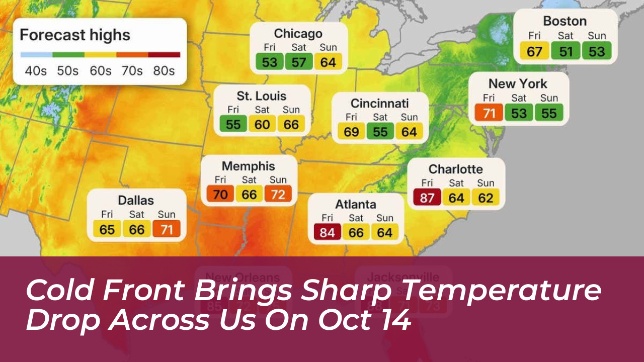

Millions of Americans across the central and eastern United States face a dramatic shift from record October heat to near-freezing morning temperatures, according to forecasts published October 14, 2026. A powerful cold front moving south and east from Canada will bring daytime highs down by as much as 40 degrees compared with early-week temperatures, with frost possible across several regions.
The National Weather Service, along with forecasts from Weather.com, FOX Weather, and AccuWeather, indicate that unusually warm conditions will persist through midweek before colder air spreads across the Great Plains, Midwest, Great Lakes, Northeast, and Southeast. More than 250 million Americans could experience the unseasonable warmth first, while some locations approach or break daily temperature records.
Record October Heat Precedes the Chill
Before the arrival of the cold blast, summer is making a powerful final stand across much of the country. According to FOX Weather and NOAA’s Weather Prediction Center, unseasonably warm weather is expanding across the central and eastern United States through Thursday, October 15, with temperatures running about 20 degrees above average.
In parts of the Midwest, temperatures will reach the upper 80s and 90s, while the Southern Plains, Mid-South, and Southeast could see highs in the mid- to upper 90s. Heat index values may exceed 100 degrees in parts of the South. AccuWeather predicts that daily high temperature records dating back more than 125 years could be challenged or broken in cities such as Chattanooga, Tennessee; Birmingham, Alabama; and St. Louis, Missouri.
Weather Whiplash: From 90s to Frost and Snowflakes
The transition will create a severe weather whiplash effect as the cold front sweeps across the country by the weekend. Highs in the South will plummet from the 80s and 90s down to the 60s and 70s. Meanwhile, the Northeast and Great Lakes will see temperatures drop to the 50s and 60s, with some scattered highs in the 40s.
“A powerful cold front is trying to loosen summer’s hold on the central Plains and Eastern U.S., and it will largely succeed,” said Weather.com meteorologist Rob Shackelford.
Morning lows will tumble into the 30s and 40s, requiring residents to bundle up and potentially scrape frost off their windshields. A storm arriving later in the week from Canada could bring the first light lake-effect snow or flurries to higher elevations in northern New York, Vermont, New Hampshire, and Maine.
How Long Will the Cold Snap Last?
Meteorologists note that this sharp cool-down will be relatively brief. A ridge of high pressure is expected to set up across the Eastern United States early next week, allowing warmer air to rebuild. While extreme summer heat is not expected to return immediately, temperatures will trend back above average following the weekend freeze.
Key Regions Impacted by the October Cold Front
- Central Plains & Midwest: Immediate drop from near-record 80s and 90s to crisp fall air and morning frost.
- Northeast & Great Lakes: Daytime highs dropping to the 50s and 40s, with potential snowflakes in higher mountain elevations.
- South & Southeast: Transition from heat index values exceeding 100 degrees down to comfortable 60s and 70s by the weekend.