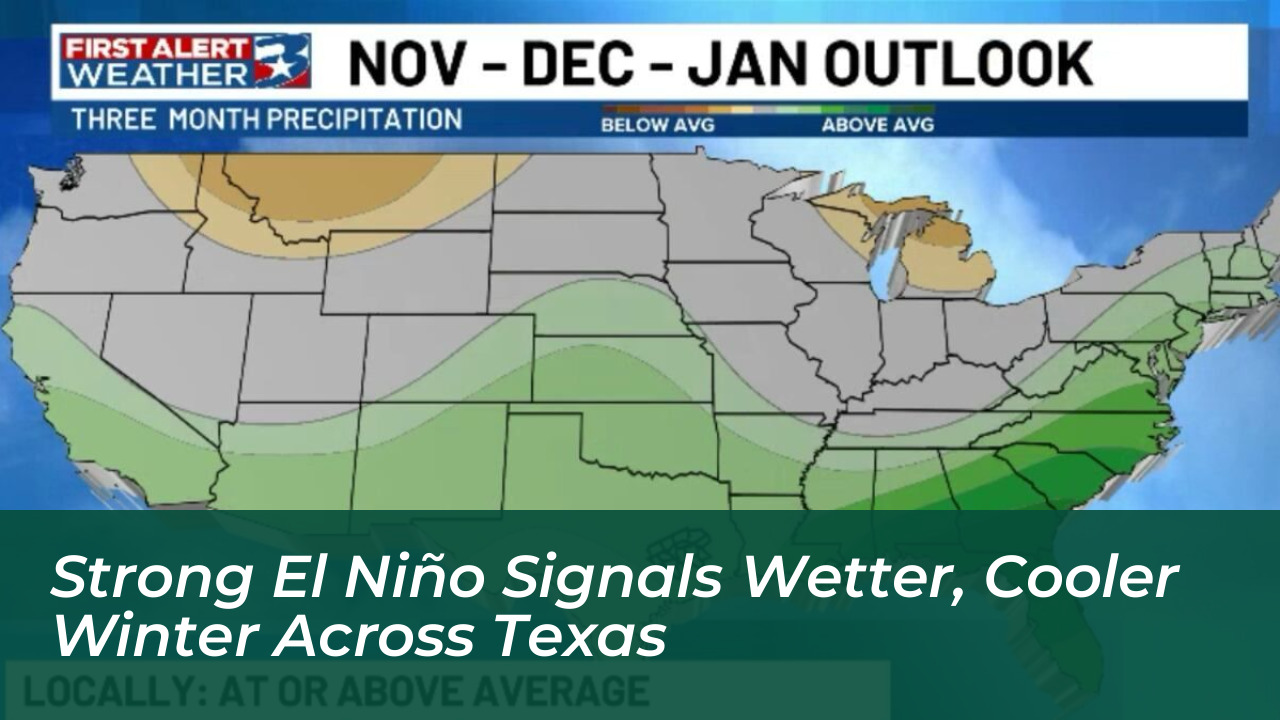

A strengthening El Niño is set to bring cooler temperatures and increased rainfall to the Brazos Valley and regions across Texas through early 2027, according to data from the National Oceanic and Atmospheric Administration (NOAA). The emerging climate outlook points toward a wetter late fall and winter season, offering potential relief to drought-stressed landscapes after several consecutive La Niña winters.
Intensifying Pacific Anomalies Signal Historic Event
NOAA’s Climate Prediction Center reported that El Niño continues to intensify rapidly. Sea-surface temperature anomalies exceed +4.0°C in parts of the eastern equatorial Pacific. Forecasters indicate that this developing climate pattern could become one of the strongest recorded events since 1950.
The Climate Prediction Center has calculated an 83% chance that a strong-to-very-strong El Niño will persist through January-March 2027. For the October-December window, meteorologists estimated an 83% chance that three-month measurements will surpass those of any recorded event since 1950. Some tracking models suggest even higher confidence thresholds.
Shifting Jet Stream Drives Regional Weather Patterns
The unusually warm Pacific waters directly influence atmospheric circulation, altering storm tracks across the United States. Ken Graham, director of NOAA’s National Weather Service, noted that historical observations point to a distinct shift in the jet stream. This shift favors stormier conditions across the southern tier of the country.
During a typical El Niño winter, the jet stream establishes itself farther south across Texas and the Gulf Coast. This shift places the Lone Star State directly in the path of repeated storm systems. Consequently, Texas winters during strong El Niño cycles tend to run cooler and wetter, while northern regions experience drier and milder conditions.
- Precipitation: NOAA’s official seasonal outlook gives most of Texas a 33% to 40% chance of above-normal precipitation. Central and East Texas face the highest probabilities early in the season.
- Temperature: Average winter temperatures are projected to dip. Statewide models show temperatures running roughly 1.2 degrees below normal from January through March.
- Snowfall: Snow chances improve across the northern half of the state, particularly in the Panhandle and Northwest Texas from January into February. Historical data indicates seasonal snowfall averages can double in parts of West Central Texas during strong El Niño phases.
Drought Relief Versus Flash Flooding Risks
Increased rainfall is generally welcomed after years of dry conditions. However, meteorologists emphasize a vital distinction: rain does not automatically equal immediate drought relief. Hardened, drought-stressed soils often shed sudden heavy rainfall rather than absorbing it. This leads to surface runoff and flash flooding risks while leaving deep soil moisture unchanged.
Mack Morris, a meteorologist with the National Weather Service Austin-San Antonio office, noted that severe weather reports typically spike during strong El Niño years. Increased cloud cover, cooler daytime highs, and the collision between cold continental air and rich Gulf moisture elevate the risk of winter and early-spring severe thunderstorms, hail, and localized flooding across Texas and Oklahoma.
Preparing for the Winter Transition
As Texas transitions through its traditional seasonal cooling, emergency managers, agricultural sectors, and residents are advised to monitor ongoing forecasts from NOAA and local National Weather Service offices. While the statistical tilt clearly favors a wetter and stormier winter, experts remind the public that seasonal outlooks describe probabilistic shifts rather than guarantees for individual storm events.