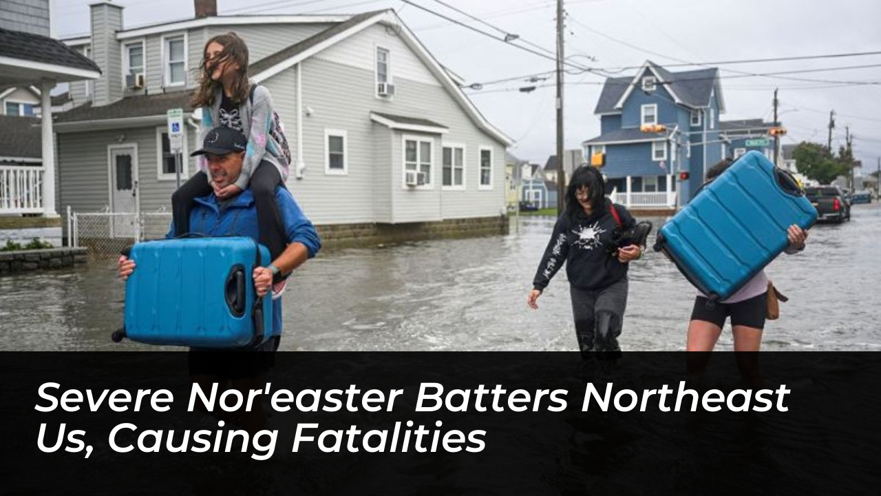
A powerful, slow-moving nor’easter slammed the northeastern United States on Saturday, September 26, 2026. This severe nor’easter unleashed torrential rainfall, destructive wind gusts topping 74 miles per hour, and historic coastal flooding across multiple states from North Carolina to Maine. Authorities in New York and New Jersey declared states of emergency as rising waters overwhelmed low-lying coastal communities, forcing evacuations and shutting down key transit infrastructure. Tragically, the extreme weather turned fatal in Brooklyn, New York, where a municipal worker lost his life amid the onslaught. Tens of thousands of homes and businesses lost electrical service as heavy winds battered saturated soils and leaf-laden trees. Meteorologists warned that the multi-day duration of the system, amplified by a peak astronomical full moon, would maintain severe hazards well into the upcoming week.
- Introduction to the September Noreaster
- Meteorological Profile and Formation of the Early-Season Storm
- Unseasonal Timing and Atmospheric Setup
- Amplifying Factors: Full Moon and Summer Foliage
- Tragic Fatality Reported in Brooklyn
- States of Emergency Declared Across New York and New Jersey
- Government Response and Mobilization
- Widespread Coastal Inundation and Tidal Flooding
- Massive Power Outages Impact Tens of Thousands
- Severe Disruptions to Aviation and Regional Transportation
- Aviation and Flight Cancellations
- Rail, Ferry, and Public Transit Halt
- State-by-State Impact Breakdown
- New York
- New Jersey
- Massachusetts and New England
- North Carolina and the Mid-Atlantic
- Economic and Public Event Disruptions
- Frequently Asked Questions
- What caused the severe nor’easter in September 2026?
- Where did the fatal incident occur during the storm?
- How high were the wind gusts recorded during the storm?
- Which states declared states of emergency?
Introduction to the September Noreaster
Nor’easters are typically associated with late autumn and winter months, making this September event unusually early and potent. The National Weather Service explains that a nor’easter develops when low-pressure systems stall off the Atlantic coast, driving sustained winds from the northeast onshore. In this instance, an upper-level low parked itself near the mid-Atlantic and New Jersey coastlines, creating a prolonged fetch of gale-force winds. Meteorologists at the National Weather Service noted that the storm’s slow forward speed compounded its destructive potential. Unlike fast-moving squalls that drop rain and depart quickly, this system delivered persistent bands of heavy precipitation and continuous onshore wave action over multiple high-tide cycles.
The presence of summer foliage still clinging to trees also worsened wind resistance, multiplying the risk of structural tree damage and widespread power failures. Saturday’s weather coincided with a peak harvest full moon, which maximized gravitational pull and generated unusually high astronomical spring tides. When combined with the storm surge driven by northeast winds, coastal waters rose several feet above normal high tide levels.
Meteorological Profile and Formation of the Early-Season Storm
Unseasonal Timing and Atmospheric Setup
The atmospheric setup for this autumn-like weather event in late September baffled casual observers, yet meteorologists tracked the rare ingredients weeks in advance. A stationary upper-level trough combined with tropical moisture plumes pulling northward from the Atlantic basin to feed the sprawling vortex. This convergence generated persistent gale-force winds that pounded coastal areas continuously for over thirty-six hours without a significant break.
Forecasters utilized advanced radar networks to monitor the slow-moving low-pressure center hovering just off the New Jersey shoreline. Because the system lacked a fast steering current in the upper atmosphere, it remained nearly stationary, recycling moisture and continuously lashing the same regions with heavy rain bands. This stationary behavior amplified rainfall totals, pushing accumulations past four inches in several localized zones.
Amplifying Factors: Full Moon and Summer Foliage
Astronomical conditions played a massive role in exacerbating the tidal surge. The peak full moon aligned perfectly with the arrival of the storm, driving water levels significantly higher than standard seasonal norms. Barrier islands and coastal marshes experienced rapid inundation as seawater pushed past dunes and sea walls during successive high tide cycles.
Deciduous trees still retained their dense green summer canopies during the storm. Heavy winds easily caught these broad leaves acting as sails, placing immense torque on root systems already weakened by saturated soil. Consequently, thousands of trees snapped or toppled entirely, taking power lines down with them and blocking major suburban roadways.
Tragic Fatality Reported in Brooklyn
The severe weather claimed one confirmed life in New York City. A 56-year-old New York City Housing Authority employee was struck and killed by a falling tree in Brooklyn as wind gusts reached dangerous levels across the five boroughs. The incident occurred near 700 Euclid Avenue around 3:30 p.m. on Saturday during the height of the gale.
Emergency responders rushed the victim to Brookdale Hospital in critical condition, where he was pronounced dead shortly after 5 p.m. The tragedy marked the first major casualty of the storm. Local law enforcement and municipal agencies immediately renewed warnings for residents to remain indoors and avoid walking or driving near mature trees and unsecured infrastructure.
City officials expressed profound condolences to the family of the fallen worker while mobilizing additional urban forestry teams to address hanging branches and unstable timber across public housing developments. The incident underscored the hidden dangers posed by seemingly stable street trees subjected to sustained high-velocity winds.
States of Emergency Declared Across New York and New Jersey
Government Response and Mobilization
Governors and local municipal leaders took swift legislative action to mobilize emergency services ahead of the storm’s peak impact. New York Governor Kathy Hochul declared a state of emergency for New York City, Long Island, and Westchester County. Officials urged residents to monitor local alerts, secure outdoor property, and refrain from non-essential travel.
Similar emergency declarations blanketed coastal counties in New Jersey, Delaware, and North Carolina. In Dare County, North Carolina, officials declared an official state of emergency for Hatteras Island. Severe ocean overwash compromised long stretches of N.C. Highway 12, cutting off all vehicular access to the island and trapping visitors and non-resident property owners.
Widespread Coastal Inundation and Tidal Flooding
Coastal communities experienced some of the worst tidal flooding since Superstorm Sandy in 2012. In Surf City, New Jersey, a wind sensor recorded a staggering peak gust of 74 miles per hour, equivalent to a Category 1 hurricane. Marina owners watched helplessly as high-value boats broke free from their lifts and were swept away by rising tides.
In Ocean City, New Jersey, and Ocean City, Maryland, residential streets transformed into navigable waterways where residents utilized kayaks, paddleboards, and specialized high-water rescue vehicles. Saltwater intrusion severely damaged vehicles parked in street-level garages, while local businesses deployed sandbags and industrial pumps to keep bay waters at bay.
Massive Power Outages Impact Tens of Thousands
The combination of saturated ground and relentless wind gusts wreaked havoc on electrical grid infrastructure throughout the Northeast. Power distribution networks reported over 100,000 active outages at the peak of the storm on Saturday afternoon. Utility crews labored under hazardous conditions to clear fallen timber and repair downed power lines.
By Saturday night, coordinated restoration efforts reduced the total number of darkened households to approximately 70,000 to 73,000. New York and Connecticut sustained the heaviest brunt of the blackouts, with tens of thousands of customers affected in each state. Utility providers warned that ongoing high winds would continue to slow down field repair operations into Sunday.

Severe Disruptions to Aviation and Regional Transportation
Aviation and Flight Cancellations
Transportation networks faced crippling delays and widespread cancellations across the entire Eastern Seaboard. FlightAware tracking data revealed more than 3,000 national flight delays and upwards of 400 total cancellations as visibility dropped and crosswinds strengthened at major hubs.
Boston Logan International Airport experienced the nation’s highest cancellation numbers, with over 250 flights grounded. Smaller regional facilities, including Nantucket Memorial Airport and Martha’s Vineyard Airport, saw cancellation rates exceed 70 percent. In New York, John F. Kennedy International Airport and LaGuardia Airport implemented ground delay programs while recording gusts over 55 miles per hour.
Rail, Ferry, and Public Transit Halt
Beyond aviation, ground and maritime transport suffered severe interruptions. Public ferry operators suspended all scheduled service connecting mainland Cape Cod to Martha’s Vineyard and Nantucket due to hazardous wave heights and turbulent conditions in Nantucket Sound.
Amtrak and regional commuter rail lines canceled select routes across Connecticut, Rhode Island, and Massachusetts following reports of downed overhead wires and debris blocking tracks. State departments of transportation deployed emergency buses where possible, but urged the public to postpone all regional travel until meteorological conditions stabilized.
State-by-State Impact Breakdown
New York
New York bore significant structural and infrastructural damage. In addition to the fatality in Brooklyn, high winds downed trees and power lines across Long Island, Queens, and Staten Island. Smithtown residents witnessed dozens of uprooted trees blocking roadways.
Flash flood warnings were triggered in low-lying residential sectors near Jamaica Bay and the Rockaways, where tidal waters pushed over bulkheads and flooded basement apartments. Municipal drainage systems struggled to keep pace with the relentless downpour.
New Jersey
The Jersey Shore took a direct hit from gale-force winds and storm surges. Coastal towns including Manasquan, Point Pleasant, Sea Bright, and Ocean City recorded severe beach erosion and property damage. Ocean County emergency management deployed specialized hovercrafts to navigate flooded residential streets.
Boardwalks and protective dunes suffered considerable wear as pounding surf chipped away at sand reinforcement projects completed earlier in the summer season.
Massachusetts and New England
Massive wave action battered coastal towns across Massachusetts, notably in Hull, where thick sea foam blew across parking lots and barrier walls. Wind gusts approached 70 miles per hour on Cape Cod, accompanied by torrential rainfall rates that flooded cellars in Bristol and Plymouth counties.
Utility poles snapped like toothpicks in Barnstable County, leaving entire seaside communities isolated until line crews cleared passage routes.
North Carolina and the Mid-Atlantic
Relentless ocean overwash battered the Outer Banks of North Carolina, washing sand and debris across vulnerable barrier island roadways. The continuous flooding forced the closure of N.C. Highway 12, severing land access to Hatteras Island and leaving residents to hunker down as rising tides cut off the transport corridor.
Economic and Public Event Disruptions
The severe weather wreaked havoc on weekend commerce and outdoor entertainment schedules. Major League Baseball officials postponed several outdoor games across the Northeast, while local organizers canceled community festivals, farmers markets, and youth sports tournaments.
Retail centers in coastal zones reported sharp drops in foot traffic as shoppers heeded emergency stay-at-home advisories. Local tourism boards noted significant economic losses for hospitality businesses relying on late-September weekend visitors.
Frequently Asked Questions
What caused the severe nor’easter in September 2026?
A slow-moving low-pressure system stalled off the Atlantic coast, combining with tropical moisture plumes and a peak astronomical full moon to generate sustained gale-force winds and coastal flooding.
Where did the fatal incident occur during the storm?
The tragic fatality occurred near 700 Euclid Avenue in Brooklyn, New York, where a municipal housing employee was struck by a falling tree.
How high were the wind gusts recorded during the storm?
Wind gusts reached a staggering 74 miles per hour in Surf City, New Jersey, matching the threshold of a Category 1 hurricane.
Which states declared states of emergency?
Governors declared states of emergency across New York, New Jersey, Delaware, and select coastal counties in North Carolina, including Dare County.