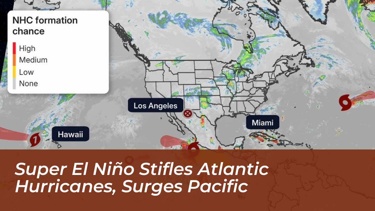
A historic super El Niño climate pattern has severely suppressed Atlantic hurricane activity as of September 30, 2026. Concurrently, it has fueled intense tropical storms across the Eastern Pacific Ocean due to elevated sea surface temperatures. High vertical wind shear and dry Saharan dust plumes across the North Atlantic have prevented tropical systems from organizing, leaving Accumulated Cyclone Energy (ACE) in the Atlantic basin at historically low levels.
- The Anatomy of a Quiet Atlantic Hurricane Season
- Eastern Pacific Storms Surge Under Record-Breaking Heat
- The Mechanics of the Super El Niño
- Frequently Asked Questions
- What is causing the lack of Atlantic hurricanes in 2026?
- How active is the Eastern Pacific basin compared to normal?
- What is Accumulated Cyclone Energy (ACE)?
- Will the Atlantic hurricane season remain completely dead?
- How does El Niño impact winter weather across the United States?
In stark contrast, the Eastern Pacific has recorded 16 named storms. These include Hurricane Nolo near Hawaii and Hurricane Polo, which made landfall in Baja California Sur before spreading heavy rainfall into the U.S. Southwest. This meteorological phenomenon presents a classic tale of two basins, highlighting how shifting global ocean temperatures dictate extreme weather patterns on opposite sides of the North American continent.

The Anatomy of a Quiet Atlantic Hurricane Season
The Atlantic hurricane season traditionally stretches from June 1 to November 30 with a peak in September, but it is experiencing unprecedented quiet. According to data tracked by meteorologists like Phil Klotzbach at Colorado State University, wind shear across key development regions of the Atlantic has reached its strongest levels on record since 1979.
Strong vertical wind shear acts like an invisible barrier. It stretches atmospheric columns and unspooling the tight circular formations required for tropical depressions to mature into hurricanes. , dry and unstable air masses brought by Saharan dust plumes traveling from Africa have sapped moisture from the atmosphere, effectively killing the heat engines that typically drive major Atlantic storms.
- Zero full-blown hurricanes recorded in the Atlantic basin by late September.
- Accumulated Cyclone Energy (ACE) sitting at a meager 4.4 compared to a norm of 51.
- Persistent high vertical wind shear preventing storm organization.
Eastern Pacific Storms Surge Under Record-Breaking Heat
While the Atlantic remains largely dormant, the Eastern Pacific Ocean is roaring with activity. Elevated sea surface temperatures-running roughly 5°C hotter than normal near storm formation zones-have provided a continuous reservoir of thermal energy.
The Eastern Pacific has documented 16 named storms, featuring multiple major hurricanes that have directly threatened regional landmasses. Hurricane Polo captured global attention by rapidly intensifying from a tropical storm into a Category 5 monster in less than 24 hours. Meanwhile, island chains have faced direct threats from systems like Hurricane Lala and Hurricane Lowell, bringing severe flooding and wind damage to Hawaii.
The Mechanics of the Super El Niño
El Niño is a natural climate oscillation that develops every two to seven years when equatorial Pacific trade winds weaken, allowing warm surface waters to pool eastward. However, the 2026 event has far exceeded standard projections, earning classifications as a “super El Niño” or “Godzilla” event comparable to historic anomalies like the 1997 season.
“We are headed toward what will almost certainly be the strongest El Niño on record,” notes Brian McNoldy, a senior research associate at the University of Miami. “It has exceeded expectations in both the Pacific and the Atlantic.”
Beyond shaping immediate tropical weather, this intense phase of the El Niño-Southern Oscillation (ENSO) alters global jet streams. Climatologists warn that as the year progresses, the Pacific’s residual heat will likely transition into a wetter, potentially snowier winter for the Southern United States and the mid-Atlantic region, increasing flood risks in drought-weary areas.
Frequently Asked Questions
What is causing the lack of Atlantic hurricanes in 2026?
The primary driver is a powerful super El Niño that generates intense vertical wind shear across the North Atlantic, tearing developing storms apart before they can organize. Additional factors include dry Saharan dust plumes and increased atmospheric stability.
How active is the Eastern Pacific basin compared to normal?
The Eastern Pacific has experienced significantly above-average activity, recording 16 named storms, including multiple major hurricanes and an Accumulated Cyclone Energy (ACE) value nearly double the historical average.
What is Accumulated Cyclone Energy (ACE)?
Accumulated Cyclone Energy is a metric used by meteorologists to measure the combined intensity and duration of tropical cyclones throughout a given season.
Will the Atlantic hurricane season remain completely dead?
While activity is exceptionally low, meteorologists caution that the season runs through November 30. It remains mathematically possible for a late-season storm to form, and communities should maintain standard weather preparedness.
How does El Niño impact winter weather across the United States?
Strong El Niño patterns typically direct a southern jet stream across North America. This often translates to wetter and potentially snowier winter conditions across the U.S. South, Southwest, and mid-Atlantic regions.