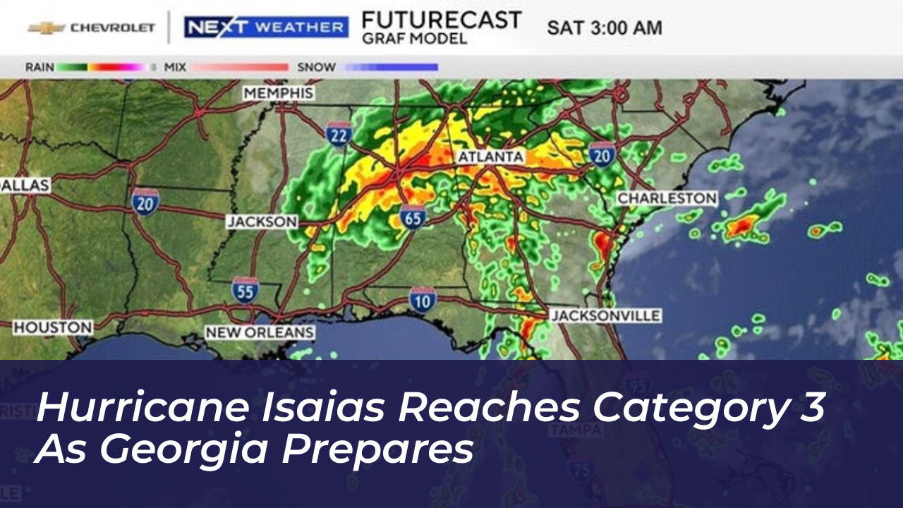

Hurricane Isaias intensified rapidly into a Category 3 major storm on Friday, October 9, 2026. It packed maximum sustained winds of 120 mph. The system moved north-northeast at 15 mph over the warm waters of the northern Gulf of Mexico. This put coastal communities on high alert for destructive winds and life-threatening storm surges while neighboring states, including Georgia, braced for severe weather.
According to updates from the National Hurricane Center (NHC) and local meteorological teams, Hurricane Hunter aircraft collected critical data confirming the storm’s intensification. Positioned approximately 240 miles south of Pensacola, Florida, ahead of its anticipated landfall near the Florida-Alabama border, Isaias prompted widespread emergency declarations, school closures, and mandatory evacuation orders across the northern Gulf Coast.
Impacts and Preparation Across Georgia
Although the exact center of Hurricane Isaias was projected to make landfall along the Florida Panhandle or southern Alabama, Georgia faced severe peripheral hazards. State emergency management officials noted that Georgia did not require a direct hit to experience damaging conditions. The eastern side of the storm system routinely generates heavy rain bands, strong wind gusts, and an elevated tornado risk.
Governor Brian Kemp declared a state of emergency for all 159 Georgia counties. This allowed state operations centers to position emergency teams and resources proactively. In metro Atlanta and North Georgia, rain showers were expected to spread north near and after sunset on Friday, with conditions deteriorating overnight into Saturday.
- Wind Threats: A high wind watch covered much of North Georgia, with anticipated gusts reaching up to 50 mph. Combined with rain-softened soil, persistent winds threatened to knock down trees and utility lines.
- Rainfall and Flooding: Rainfall totals across North Georgia were forecast between 1 to 3 inches. Meanwhile, southwest Georgia regions faced flood watches with heavier potential downpours.
- Tornado Potential: FOX 5 Storm Team forecasters warned of an overnight and all-day Saturday tornado threat spanning across central and northern portions of the state.
Florida and Alabama Coastline Braces for Landfall
Communities along the Florida Panhandle, including Pensacola and Destin, faced the brunt of the storm’s most severe impacts. Florida Governor Ron DeSantis declared a state of emergency for 25 counties. Local authorities in Escambia, Okaloosa, and Walton counties also ordered mandatory evacuations for vulnerable low-lying neighborhoods.
Forecasters warned that storm surge could push seawater up to 9 feet above ground level in specific zones between the Santa Rosa-Okaloosa county line and Grayton Beach. Bridge closures, including the Pensacola Bay Bridge and Bob Sikes Bridge, were planned as winds approached unsafe thresholds.
In neighboring Alabama, Governor Kay Ivey declared an emergency for 40 counties. Coastal cities such as Gulf Shores, Orange Beach, and Dauphin Island issued mandatory evacuation orders for tourists and nonresidents. Southern Alabama braced for hurricane-force wind gusts extending up to 100 miles inland, threatening widespread electrical outages and structural damage.
Category 3 Storm Mechanics
A Category 3 hurricane features sustained winds ranging from 111 to 129 mph, making it officially a major hurricane. Meteorologists emphasized that a storm’s category strictly measures maximum sustained wind speed around its inner core. It does not quantify rainfall amounts, coastal storm surge, or the formation of embedded tornadoes.
Even if upper-level winds force Isaias to downgrade slightly to a Category 2 or Category 1 system just before touching land, forecasters stressed that weakening intensity does not eliminate life-threatening hazards. Inland flooding, prolonged wind gusts, and severe weather bands continue to pose significant risks long after a storm moves ashore.
Safety Guidelines and Emergency Response
Emergency management agencies urged residents in threatened zones to complete preparations before conditions worsened on Friday afternoon:
- Charge mobile devices and backup power banks, and check flashlights.
- Secure outdoor furniture, decorations, and loose objects.
- Ensure reliable weather alert systems are enabled to wake sleeping individuals for overnight tornado warnings.
- Stock emergency supplies including non-perishable food, bottled water, and necessary prescription medications.
- Comply immediately with local evacuation orders before rising water levels block critical evacuation routes.
As the storm progresses inland through the weekend, its remnants are expected to carry heavy rain and localized flooding risks as far north as Tennessee and North Carolina. This will extend the reach of Isaias well beyond the Gulf Coast.