
The Washington, D.C., area is experiencing an unseasonable surge of warmth, with temperatures on Wednesday threatening to break long-standing records. While the calendar marks mid-October, daytime conditions are bringing a late-summer feel to the region, featuring forecast highs in the upper 80s to near 90 degrees paired with elevated humidity levels.

Record-Breaking October Heat Forecast
According to the National Weather Service and local meteorological reports, the heat wave is driven by an unusually strong high-pressure ridge shifting eastward from the central United States. Forecast highs for Washington, D.C., Dulles Airport, and Hagerstown are on pace to challenge or tie records originally set in 1975, while Winchester could exceed its historical record from 1989.
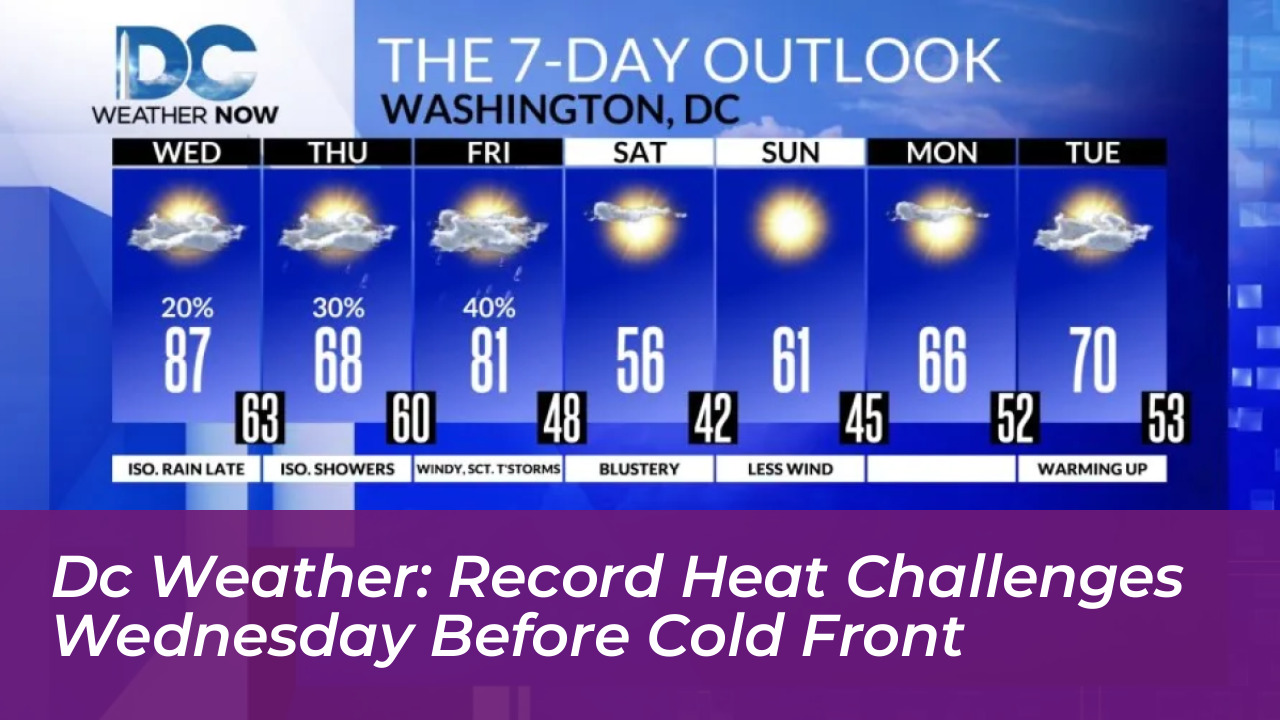
At Reagan National Airport, the daily record for the date is 87 degrees, set in 1975. Forecasters note that actual afternoon temperatures could reach 88 to 89 degrees. When combined with dew points in the mid-to-upper 60s, heat index values may climb into the lower 90s.
Meteorologists point out another historic milestone: Washington, D.C., has not reached 90 degrees after October 11 in records dating back 154 years. If temperatures hit the 90-degree mark on Wednesday, it will stand as the latest 90-degree day ever recorded in the city.
Evening Showers, Thunderstorms, and Cold Front Arrival
The unseasonably warm spell will be short-lived as a potent cold front approaches from the west. Dry conditions are expected through much of the daytime hours on Wednesday, but changes arrive by evening.
Isolated showers and a few thunderstorms could develop in northern counties later in the afternoon. More widespread scattered showers and potential thunderstorms are expected late Wednesday night into early Thursday morning as the cold front clears the region, potentially impacting the Thursday morning commute.
A Dramatic Drop to Fall Chill and Weekend Frost
The passage of the cold front will trigger a sharp and immediate temperature drop across the Mid-Atlantic. Thursday will turn noticeably cooler and mostly cloudy, with daytime high temperatures restricted to the 60s along with patchy drizzle.
By the weekend, the region will experience a true autumn transition. Saturday is expected to be windy and blustery with daytime highs struggling to reach the 50s, while overnight lows heading into Sunday morning could dip into the upper 30s and lower 40s, bringing the season’s first widespread threat of frost to parts of the Washington, D.C., metropolitan area.
Frequently Asked Questions
What is the forecast high for Washington D.C. on Wednesday?
Forecasters expect daytime highs to reach the upper 80s, around 88 to 89 degrees, which threatens daily records.
What previous heat records are being challenged?
The daily record for the date at Reagan National Airport is 87 degrees, set in 1975. Additionally, meteorologists are watching to see if the city hits 90 degrees, which would make it the latest 90-degree day recorded in D.C. history.
When will the cold front arrive?
The cold front is expected to move through the region late Wednesday night into Thursday morning, bringing scattered showers, thunderstorms, and much cooler air.
What kind of temperatures can we expect by the weekend?
Temperatures will drop significantly by the weekend, with daytime highs lingering in the 50s on Saturday and overnight lows falling into the upper 30s and lower 40s by Sunday morning.