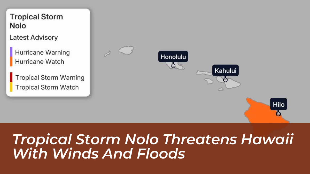
Tropical Storm Nolo is tracking north through the Central Pacific, posing a severe atmospheric and hydrological threat to the Hawaiian archipelago. As of September 24, 2026, the approaching system demands immediate attention from residents, emergency managers, and utility providers as heavy rainbands begin to impact the islands.
- Meteorological Overview of Tropical Storm Nolo
- Current Location and Track Dynamics
- Intensity Projections and Rapid Strengthening
- Rainfall Projections and Catastrophic Flooding Risks
- Precipitation Totals by Island
- Saturated Soils and Historical Vulnerability
- Wind Hazards, Power Grid Vulnerability, and Structural Pressures
- Wind Speed Expectations and Downslope Accelerations
- Utility Outages and Grid Recovery Challenges
- Coastal Flooding, High Surf, and Marine Disruptions
- Storm Surge and Coastal Inundation
- Maritime Disruptions and Event Cancellations
- Comparison With Historical Central Pacific Hurricanes
- Rarity of Major Hurricanes Near Hawaii
- The Role of El Niño in the 2026 Season
- Actionable Emergency Preparedness Checklist
- Property Mitigation and Safeguarding
- Supplies and Communications
- Frequently Asked Questions
- Is Tropical Storm Nolo guaranteed to make landfall on the Big Island?
- How much rainfall is expected from Tropical Storm Nolo?
- Why is Hawaii experiencing so many tropical systems this season?
Meteorological Overview of Tropical Storm Nolo
As of September 24, 2026, the system is situated approximately 300 miles south of the Big Island. Sustained wind speeds have increased steadily as the cyclone moves through an environment characterized by low vertical wind shear and high ocean heat content. Meteorological agencies, including the Central Pacific Hurricane Center and the National Weather Service in Honolulu, have issued hurricane watches for the Big Island.
Forecasters project that Nolo will reach official hurricane status by Thursday night. Atmospheric models indicate further rapid intensification over the weekend, with the storm potentially attaining Category 3 major hurricane status before executing a sharp westward turn. While recent ensemble model runs have shifted the core track slightly farther south, meteorologists emphasize that destructive impacts will extend well beyond the central forecast cone. Outer rainbands are already delivering heavy moisture across parts of the state, testing infrastructure still recovering from earlier seasonal storms.
Current Location and Track Dynamics
- Positioned approximately 300 miles south of the Big Island, tracking north through the Central Pacific.
- Favorable atmospheric environment featuring low vertical wind shear and high ocean heat content driving sustained wind growth.
- Hurricane watches issued by the Central Pacific Hurricane Center and the National Weather Service in Honolulu.
Intensity Projections and Rapid Strengthening
- Expected to reach hurricane status by Thursday night with subsequent rapid intensification over the weekend.
- Potential to attain Category 3 major hurricane status before executing a sharp westward turn.
- Outer rainbands already delivering heavy moisture across parts of the island chain, testing storm-weary infrastructure.
Rainfall Projections and Catastrophic Flooding Risks
The primary hazard associated with Tropical Storm Nolo is torrential rainfall rather than direct landfall winds. According to peak rainfall forecasts issued by NOAA’s Weather Prediction Center, extreme precipitation amounts will target steep mountain slopes across the eastern islands. The Big Island faces the highest threat, with projected rainfall totals reaching up to 35 inches in localized interior and windward zones. Maui could receive up to 20 inches of precipitation, while the remaining Hawaiian islands brace for up to 6 inches. This volume of water falling on saturated ground creates a high potential for life-threatening flash floods, severe river overflows, and deep mudslides.
National Weather Service warning coordination meteorologists point out that the southeastern slopes of the Big Island remain exceptionally vulnerable. Hurricane Lala struck the same region in mid-August, depositing immense rainfall totals and leaving soils supersaturated. Subsequent systems, including Tropical Storm Moke and Hurricane Lowell, maintained elevated water tables across the island chain. Even minor rainbands from Nolo threaten to trigger immediate runoff and slope failures.
Precipitation Totals by Island
- Big Island faces up to 35 inches of rain in localized interior and windward zones.
- Maui projected to receive up to 20 inches of precipitation.
- Remaining Hawaiian islands brace for up to 6 inches of rainfall.
Saturated Soils and Historical Vulnerability
- Southeastern slopes of the Big Island remain exceptionally vulnerable following Hurricane Lala in mid-August.
- Subsequent systems like Tropical Storm Moke and Hurricane Lowell maintained elevated water tables across the state.
- High potential for life-threatening flash floods, severe river overflows, and deep mudslides.
Wind Hazards, Power Grid Vulnerability, and Structural Pressures
Although the forecast track has trended slightly southward, keeping the center of circulation potentially offshore, tropical-storm-force winds spanning 39 mph or higher remain likely across the southern portion of the Big Island. Gusts may reach hurricane force if the core wobbles northward closer to the coastline. Higher elevations and areas downwind of mountain slopes face accelerated downslope winds capable of snapping utility poles, tearing off roofing materials, and downing mature trees.
Utility providers across the state have mobilized emergency crews, but lingering outages from Hurricane Lowell complicate ongoing preparations. Kauai’s electric cooperative and Hawaiian Electric report that isolated households remain off the grid from previous storms. Prolonged power outages are expected in areas directly clipped by Nolo’s wind field. Residents must secure outdoor property, clear drainage gutters, and stockpile nonperishable food and potable water before conditions deteriorate.
Wind Speed Expectations and Downslope Accelerations
- Tropical-storm-force winds spanning 39 mph or higher likely across the southern portion of the Big Island.
- Gusts may reach hurricane force if the core wobbles northward closer to the coastline.
- Higher elevations and downwind slopes face accelerated downslope winds capable of snapping utility poles.
Utility Outages and Grid Recovery Challenges
- Utility providers including Kauai’s electric cooperative and Hawaiian Electric mobilizing emergency crews.
- Lingering outages from Hurricane Lowell complicate ongoing preparations and heighten vulnerability.
- Prolonged power outages expected in areas directly clipped by Nolo’s wind field.
Coastal Flooding, High Surf, and Marine Disruptions
Marine hazards will escalate rapidly as larger swells generated by Nolo propagate across the Central Pacific basin. Destructive surf and hazardous rip currents are forecast to arrive along east-facing and south-facing shores by Friday. Coastal areas near the Big Island face dangerous storm surges ranging from 1 to 3 feet above normal tide levels. Combined with high astronomical tides, these surges will produce significant coastal flooding, beach erosion, and roadway inundation in low-lying coastal communities.
The maritime threat has already forced widespread cancellations of commercial and recreational ocean activities. Notably, organizers of the annual Na Wahine O Ke Kai world championship women’s canoe race, scheduled for Sunday, September 27, canceled the historic Molokai-to-Oahu event due to extreme offshore sea states. Commercial ports are implementing heavy weather protocols, and vessel operators have been advised to seek secure harbors immediately.
Storm Surge and Coastal Inundation
- Destructive surf and hazardous rip currents arriving along east-facing and south-facing shores by Friday.
- Storm surges ranging from 1 to 3 feet above normal tide levels combined with high astronomical tides.
- Significant coastal flooding, beach erosion, and roadway inundation in low-lying areas.
Maritime Disruptions and Event Cancellations
- Commercial ports implementing heavy weather protocols and advising vessel operators to seek secure harbors.
- Cancellation of the annual Na Wahine O Ke Kai world championship women’s canoe race scheduled for Sunday, September 27.
Comparison With Historical Central Pacific Hurricanes
Tropical Storm Nolo’s projected intensity places it in a rare historical tier for the Hawaiian islands. According to NOAA historical hurricane databases, only one major hurricane has tracked within 150 miles of the Big Island since reliable record-keeping began in the mid-20th century. That system was Hurricane Dot in August 1959, which brushed the south side of the Big Island before making landfall on Kauai. If Nolo achieves Category 3 status near the island chain, it will mark the most significant major hurricane impact for the Big Island in 67 years.
The 2026 hurricane season stands out as exceptionally active for the Central Pacific, driven in large part by persistent El Niño conditions. El Niño patterns promote anomalous ocean water warming and alter wind configurations, creating an atmospheric environment highly favorable for tropical cyclogenesis and storm survival. Nolo represents the fourth tropical cyclone to directly or indirectly affect Hawaii this season, following Lala, Moke, and Lowell.
Rarity of Major Hurricanes Near Hawaii
- Only one major hurricane has tracked within 150 miles of the Big Island since reliable record-keeping began in the mid-20th century.
- Comparison to Hurricane Dot in August 1959, which brushed the south side of the Big Island before making landfall on Kauai.
- Potential for Nolo to mark the most significant major hurricane impact for the Big Island in 67 years.
The Role of El Niño in the 2026 Season
- Exceptional activity driven by persistent El Niño conditions in the Central Pacific.
- Anomalous ocean water warming and altered wind configurations favoring tropical cyclogenesis.
- Nolo as the fourth tropical cyclone to affect Hawaii this season following Lala, Moke, and Lowell.
Actionable Emergency Preparedness Checklist
With time running out before the onset of gale-force winds and torrential rain, emergency management agencies advise residents to finalize preparations immediately. Securing your environment properly prevents structural damage and personal injury.
Store adequate survival goods and monitor official channels constantly. Review your family emergency plan so everyone knows evacuation routes and shelter locations before communication lines fail.
Property Mitigation and Safeguarding
- Secure all outdoor patio furniture, potted plants, and loose construction materials that could become airborne projectiles in high winds.
- Clear residential storm drains, culverts, and roof gutters to allow heavy runoff to escape away from building foundations.
Supplies and Communications
- Store a minimum of one gallon of drinking water per person per day for at least seven days, alongside nonperishable food items that require no cooking.
- Charge all mobile communication devices, backup power banks, and emergency NOAA weather radios fully.
- Fill vehicle fuel tanks and park cars away from large trees, utility lines, and known flood zones.
Frequently Asked Questions
Is Tropical Storm Nolo guaranteed to make landfall on the Big Island?
No. While current forecast models indicate that the storm will track close to the Big Island as a major hurricane before turning sharply west, recent computer runs have pulled the center slightly farther south. However, severe meteorological impacts like heavy rain and strong surf extend far beyond the center regardless of a direct landfall.
How much rainfall is expected from Tropical Storm Nolo?
According to forecasts by NOAA, the Big Island faces up to 35 inches of rain in localized interior zones, Maui could receive up to 20 inches, and the remaining islands brace for up to 6 inches of precipitation.
Why is Hawaii experiencing so many tropical systems this season?
The active Central Pacific season is driven by persistent El Niño conditions, which warm ocean waters and reduce destructive vertical wind shear, creating an ideal environment for tropical storm formation and survival.