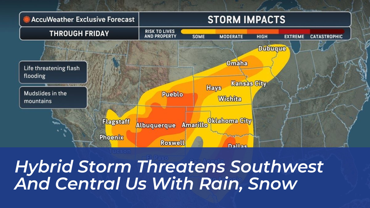
A sprawling hybrid storm system is delivering heavy rainfall and bringing up to 8 inches of snow to the highest elevations of the Colorado Rockies, according to forecasts from the National Weather Service. The major weather event combines residual moisture from the remnants of Hurricane Polo with a secondary storm moving in from the West. This drives a multi-day rainfall and flooding pattern across the Southwest, southern Plains, and Midwest.
Meteorologists warn that the incoming precipitation follows recent heavy rain events in the Southwest. This significantly heightens the danger of localized flash flooding across several states. The storm is forecast to impact a massive swath of the country, stretching from Arizona all the way to Chicago over the course of several days.
How the Hybrid Storm Formed
The system was designated as a “hybrid storm” by AccuWeather meteorologist Alyssa Glenny. It combines the remnants of Hurricane Polo-which battered the west coast of Mexico-with a separate, sprawling upper-level low moving in from the West. Marc Chenard, a meteorologist with NOAA’s Weather Prediction Center, noted that this western trough helps funnel plentiful moisture northward from the Gulf of Mexico.
“Pacific tropical moisture will wrap into a storm over the southwest U.S. and will continue a multi-day heavy rainfall event this week that will extend into the Midwest and southern Plains,” the National Weather Service stated. Experts pointed out that even without Hurricane Polo, a heavy rain and flood threat would still exist in the central United States due to the strength of the incoming low-pressure system.
Severe Flash Flooding Concerns and Predecessor Rain Events
Flooding risks are being exacerbated by what meteorologists call a “predecessor rain event” (PRE). This phenomenon occurs when a swath of heavy rain develops hundreds of miles ahead of a tropical cyclone as moisture interacts with other weather systems. Michael Lowry, a hurricane specialist with WPLG-TV, noted that a PRE has been shaping up over the Four Corners region courtesy of abundant tropical air streaming northward from Polo and the remnants of Hurricane Odalys.
“In some places, especially in New Mexico, this may be the most dangerous flash flooding risk in the last 5 years or more,” said AccuWeather chief meteorologist Jon Porter. Significant flash flooding impacts are expected near burn scars, low-water crossings, and areas with complex terrain where ground conditions are already heavily saturated from previous storms.
Heavy Snow Forecast in the Colorado Rockies
While most of the impacted regions will experience heavy rain, higher elevations are seeing some of the earliest snow events of the season. Snow levels during the storm generally hover between 11,000 and 12,000 feet, meaning mostly lightly populated areas will see accumulating snow.
High-end forecast maps from the National Weather Service offices in Pueblo and Denver indicate that up to 8 inches of snow could fall in locations such as the Sangre de Cristo Mountains, near Westcliffe, and south of La Veta Pass toward Trinidad. Mountain passes including Monarch, Wolf Creek, and La Veta are facing potential driving hazards as wet snow turns icy overnight and during early morning hours.
Regions at Greatest Risk
While rain is expected across a broad corridor from Arizona through Chicago, the heaviest precipitation bands are targeting specific zones:
- Southwest and Four Corners: High risk of severe flash flooding in New Mexico, eastern Arizona, and southwestern Colorado.
- Southern Plains and Texas: Heavy bands of rainfall threatening central Texas and southern Oklahoma with urban and river flooding starting mid-week.
- Midwest: Eastern Nebraska and western Iowa facing potential flash and urban flooding by midweek.
- High Elevations: Up to 8 inches of snow expected in the highest peaks of the Colorado Rockies.
The National Weather Service advises residents in affected regions to monitor local forecasts closely, avoid traveling through flooded roadways, and heed the warning: “Turn around, don’t drown.”