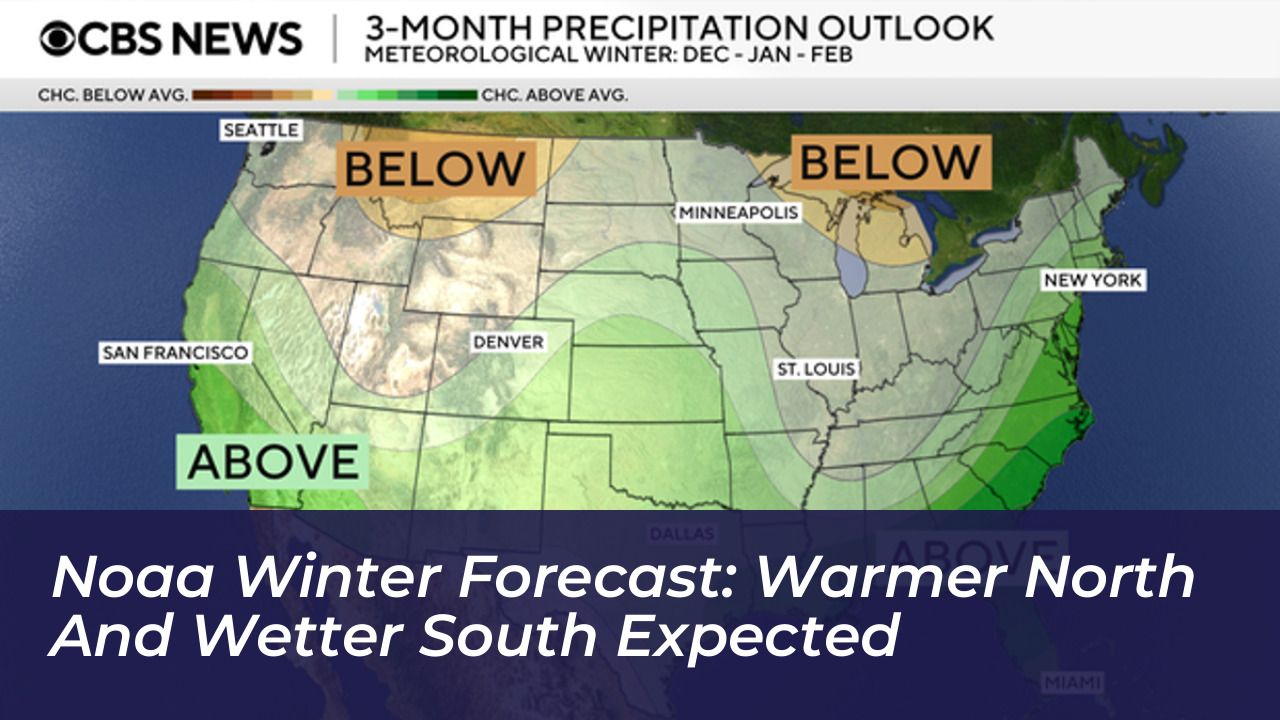

A powerful El Niño will heavily influence United States weather patterns from December 2026 through February 2027. The National Oceanic and Atmospheric Administration (NOAA) released this official winter outlook on October 15, 2026. The seasonal forecast predicts unusual warmth across the nation’s northern tier alongside increased precipitation and storminess across the southern United States and the Eastern Seaboard.
The Climate Prediction Center states that this recurring climate phenomenon will drive a southward and eastward shift in the jet stream. This atmospheric change tilts the odds toward stormier weather across the southern tier, spanning from California through Florida and moving up along the Atlantic coastline.
Temperature Outlook: Where Will It Be Warmer?
The 2026-2027 seasonal assessment indicates that no part of the United States is favored to experience a colder-than-normal winter. Instead, warmer-than-normal temperatures are heavily favored across northern California, the Pacific Northwest, the Midwest, the Mississippi Valley, much of the East, Alaska, and Puerto Rico or the U.S. Virgin Islands.
- Warmer-than-average: Pacific Northwest, Great Lakes, Midwest, New England, and parts of Alaska.
- Near-normal: Parts of the Southeast, including Florida.
- Equal chances: Hawaii and much of the Southwest, meaning temperatures could trend below, near, or above average.
Precipitation and Drought Expectations
The northern Rockies and parts of the northern Great Lakes are favored to experience drier-than-average conditions. Meanwhile, the rest of the southern tier faces elevated risks of heavy precipitation. NOAA officials caution that while rain and snow will offer relief to dry regions, excessive moisture falling on dry soil can quickly trigger flash floods and mudslides.
Drought conditions are anticipated to improve or completely end across the Southwest, the Southern Great Plains, the Southeast, and sections of the East Coast. Conversely, drought conditions are favored to develop or worsen across parts of the northern Rockies, northeastern Oregon, and eastern Washington.
“As we know from decades of observations, a very strong El Niño will likely bring a southward and eastward shift to the jet stream for the contiguous U.S., which tilts the odds toward stormier weather across the South,” said Ken Graham, director of NOAA’s National Weather Service.
New Forecasting Tools and Warnings for 2026-2027
To help communities prepare for severe weather events, NOAA has integrated updated forecasting resources for the current winter season:
- Probabilistic Precipitation Portal: An operational platform allowing emergency managers to view low-end, expected, and high-end amounts of snow, ice, and rain via interactive maps and tables.
- Particularly Dangerous Situation Wording: The National Weather Service will apply specialized language in select Blizzard Warnings and Ice Storm Warnings to denote high-confidence weather events of historic severity.
NOAA reminds the public that seasonal outlooks project broader trends in temperature and precipitation rather than specific snowfall totals. Because snow forecasts depend heavily on individual storm tracks and cold air availability, reliable snow predictions remain limited to a window of about one week in advance.